မုတ္တမပင်လယ်ကွေ့

မုတ္တမပင်လယ်ကွေ့


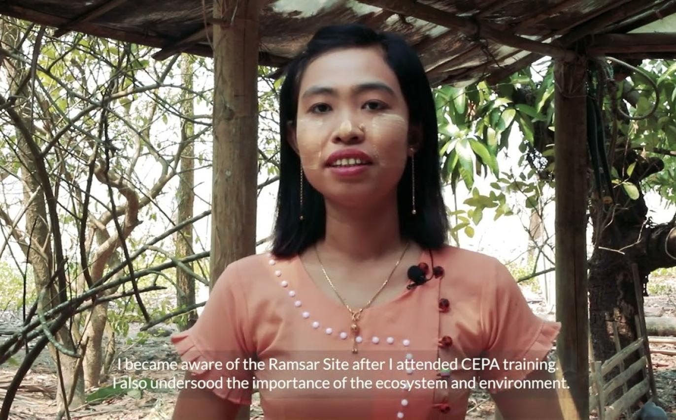
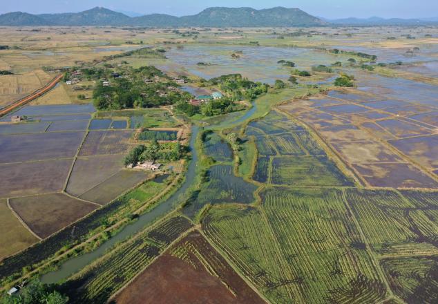
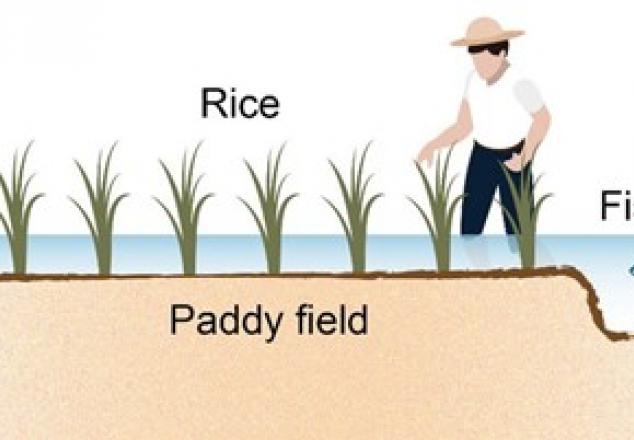
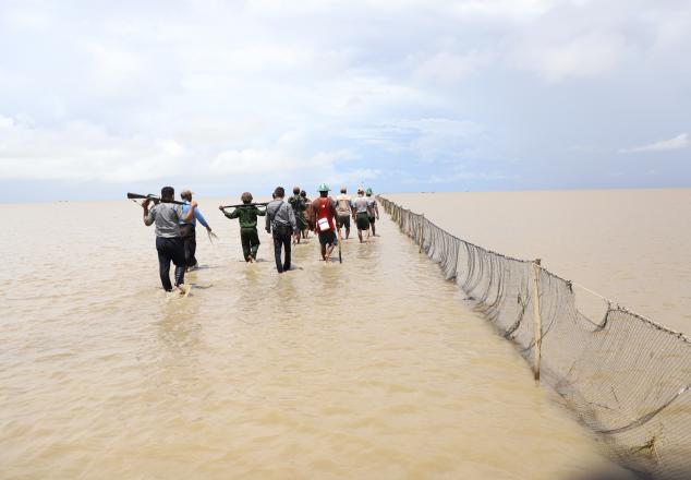
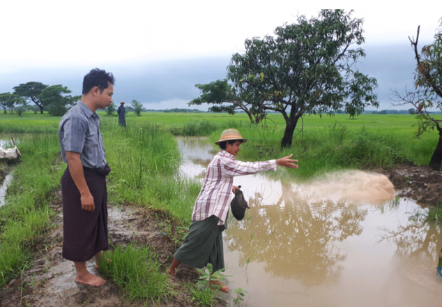
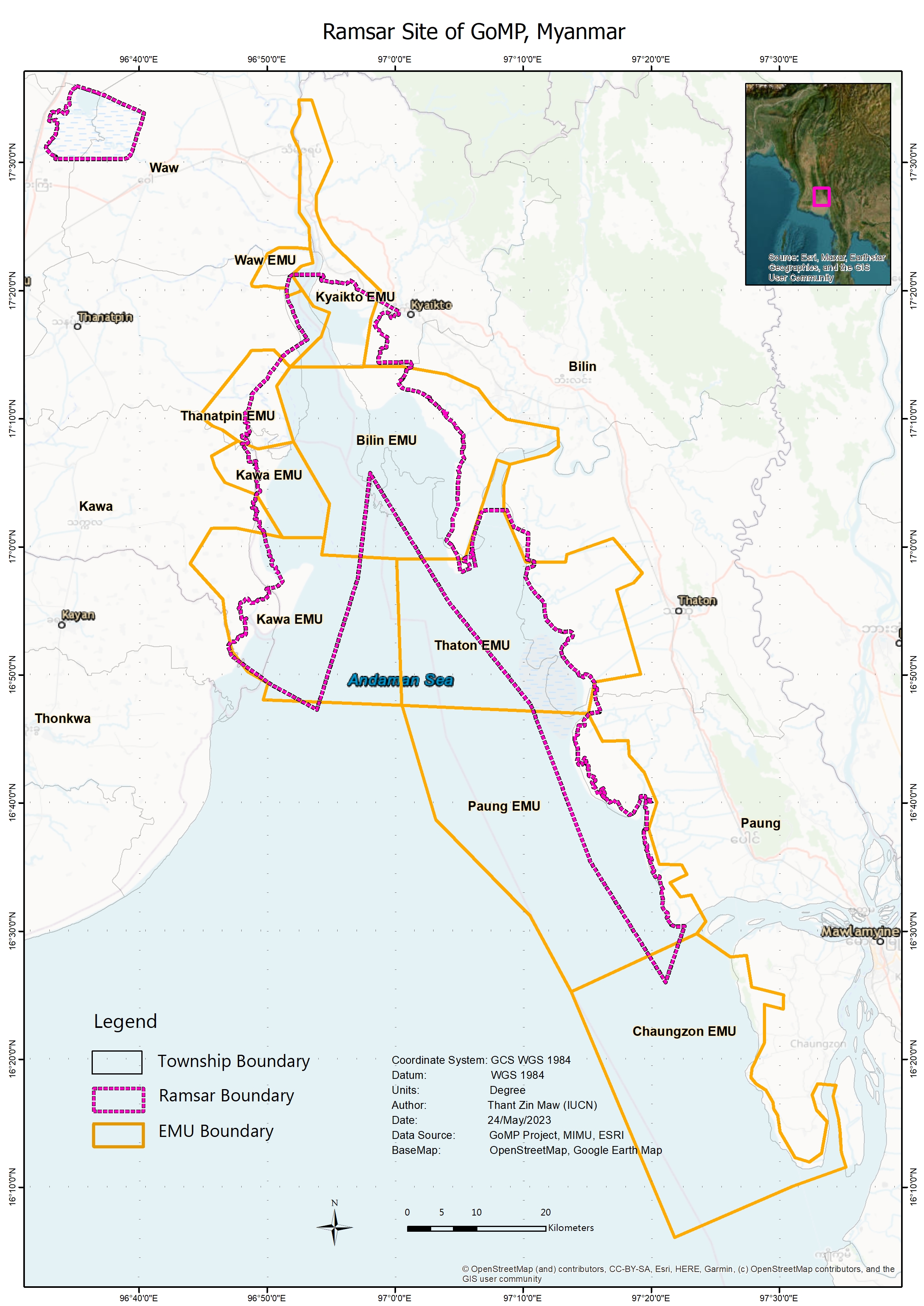
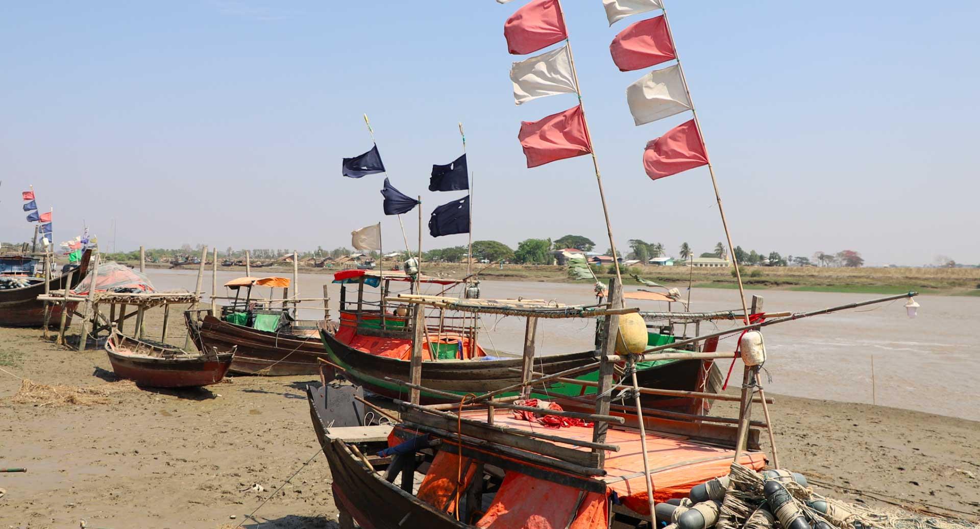
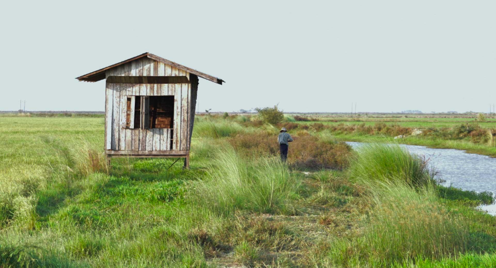
ကမ္ဘာပေါ်တွင် အရေးကြီးဆုံးနှင့် အလွန်တရာထူးခြားလှသည့် ဒီရေအတက်အကျရှိသော ရေဝပ် ဒေသများအနက် မုတ္တမပင်လယ်ကွေ့ဒေသလည်း တစ်ခုအပါအဝင်ဖြစ်ပါသည်။ ထိုသို့ထူးခြား၍ လည်း ၂၀၁၇ ခုနှစ်တွင် ရမ်ဆာဒေသအဖြစ် သတ်မှတ်ခြင်းခံခဲ့ရပါသည်။ မုတ္တမပင်လယ်ကွေ့ဒေသ သည် ထိန်းသိမ်းကာကွယ်စောင့်ရှောက်ရန်လိုအပ်သည့် အရေးပါသော သက်ရှိများနှင့် မျိုးစိတ်များ မှီခိုရာအသိုက်အမြုံ၊ စီးပွားရေးအရအရေးပါသည့် ရေလုပ်ငန်းများ ဆောင်ရွက်ရာနေရာ၊ ထိုဒေသ တွင်ရှိသည့် သဘာဝသယံဇာတအရင်းအမြစ်များအပေါ် မှီခိုနေရသည့် ဒေသခံပြည်သူများ အားထား ရာနေရာလည်း ဖြစ်ပါသည်။ ထိုဒေသရှိ သယံဇာတများနှင့် ဒေသခံပြည်သူများသည် အခက်အခဲ များစွာနှင့် ကြုံတွေ့နေရပါသည်။ ငါးသယံဇာတ လျော့နည်းလာခြင်း၊ ဆောင်းခိုငှက်များအား ဖမ်းဆီးပစ်ခတ်ခြင်း၊ ကျက်စားရာနေရာ ရှားပါးပျက်စီးလာခြင်း၊ ဒေသခံပြည်သူများအတွက် အလုပ် အကိုင်အခွင့်အလမ်းနှင့် ဝန်ဆောင်မှုများ အကန့်အသတ်ရှိခြင်း၊ ပင်လယ်ကွေ့၏ အနောက်ဘက် ကမ်းတစ်လျှောက် ဆိုးဝါးပြင်းထန်လှသည့်မြေပြိုမှုကြောင့် စိုက်ပျိုးမြေများ ပျက်စီးဆုံးရှုံးခြင်းနှင့် ဒေသခံများ နေရာရွှေ့ပြောင်းနေထိုင်ရခြင်းတို့ ဖြစ်ပါသည်။

မုတ္တမပင်လယ်ကွေ့ဒေသရှိ သဘာဝသယံဇာတများနှင့် ဒေသခံပြည်သူများ၏ လူနေမှုဘဝများကို ကာကွယ်စောင့်ရှောက်နိုင်ရန်အလို့ငှာ ဂေဟစနစ်များ၊ အသက်မွေးဝမ်းကြောင်းလုပ်ငန်းများနှင့် အုပ်ချုပ်ထိန်းသိမ်းမှုတို့ကို စီမံဆောင်ရွက်ပေးရမည်ဖြစ်သည်။ မြန်မာနိုင်ငံအစိုးရကလည်း မုတ္တမ ပင်လယ်ကွေ့ဒေသအား စနစ်တကျကိုင်တွယ်ဖြေရှင်းခြင်း၏ အရေးပါပုံကို အသိအမှတ်ပြု လက်ခံထားပြီးဖြစ်ပါသည်။ ထိုနည်းတူစွာပဲ မွန်ပြည်နယ်နှင့် ပဲခူးတိုင်းဒေသကြီးအစိုးရအဖွဲ့များ၊ ကမ်းရိုး တန်းဒေသဆိုင်ရာအဖွဲ့အစည်းများ၊ တက္ကသိုလ်များ၊ ပုဂ္ဂလိကကဏ္ဍနှင့် ပြည်တွင်းပြည်ပအဖွဲ့အစည်းများကလည်း အလွန်အမင်း စိတ်ဝင်စားကြပါသည်။ ထိုသို့အားပေးထောက်ခံမှုများသည် မုတ္တမပင်လယ်ကွေ့ဒေသအတွက် ထိရောက်မှုရှိသည့် သဘာဝသယံဇာတစီမံခန့်ခွဲရေးကို အကောင် အထည်ဖော်နိုင်ရန် အခွင့်အလမ်းကောင်းပင်ဖြစ်ပါသည်။

Embedded thumbnail for CEPA Awareness

This video is about CEPA awareness to improve community knowledge and practices on the overexploitation of coastal natural resources, biodiversity conservation, and ecosystem services. The Gulf of Mottama became the fourth Ramsar site in Myanmar in 2017.

Embedded thumbnail for ငါးသယံဇာတတိုက်ပွဲ

"ငါးသယံဇာတတိုက်ပွဲ"သည် လက်ရှိမုတ္တမပင်လယ်ကွေ့တွင် ရေရှည်တည်တံ့ရေးကို ခြိမ်းခြောက်ခြင်းခံရနေသော ငါးသယံဇာတထုတ်ယူမှုနှင့် ၎င်းတို့၏ စိန်ခေါ်မှုများအကြောင်းကို ထင်ဟပ်ပေါ်လွန်အောင် ရိုက်ကူးဖော်ပြပေးသော မှတ်တမ်းရုပ်ရှင် ဗီဒီယိုတစ်ခုဖြစ်ပါသည်။...

Embedded thumbnail for အပြည်ပြည်ဆိုင်ရာလက်ဆေးရေးနေ့

ယနေ့သည် အပြည်ပြည်ဆိုင်ရာလက်ဆေးရေးနေ့ ဖြစ်ပါသည်။ သို့ဖြစ်၍ Wide Horizons မှ ကျောင်းသားကျောင်းသူများက အိမ်တွင်းဖြစ်ဆပ်ပြာလုပ်နည်းနှင့် လက်ဆေးနည်း ၇ ဆင့်တို့ကို ရိုက်ကူးထားသည့် ဗွီဒီယိုကို မျှဝေလိုပါသည်။ ဤအစီအစဉ်ကို မုတ္တမပင်လယ်ကွေ့စီမံချက်က ပံ့ပိုး ကူညီပေးပါသည်။

1 Mar 2022
ကျေးရွာလူထုဒေသခံများအား အသိပညာနှင့် ဗဟုသုတများရရှိလာအောင် လုပ်ဆောင်ရသည့်လုပ်ငန်းသည် အမြင်အရ လွယ်ကူရိုးရှင်းနိုင်သော်လည်း လက်တွေ့ တွင်မူ မလွယ်ကူပါ။
9 Sep 2021
ငါးနှင့်စပါးတွဲဖက်မွေးမြူခြင်းကို လွန်ခဲ့သည့်နှစ်ပေါင်း၂၀၀၀ ခန့်ကပင် တရုတ်ပြည်မှစတင်လုပ်ကိုင်ခဲ့ပြီး ထိုမှတဆင့် အင်ဒိုနီးရှား၊ ဗီယက်နမ်၊ ထိုင်း၊
7 Sep 2021
မုတ္တမပင်လယ်ကွေ့ဒေသသည် ငါးသယံဇာတ လွန်စွာပေါကြွယ်ဝပြီး မြန်မာနိုင်ငံ ၄ ခုမြောက် ရမ်ဆာရေဝပ်ဒေသအဖြစ် (၂၀၁၇)ခုနှစ်တွင် သတ်မှတ်ခဲ့ပြီး (၂၀၂၀) ခုနှစ်တွင်
4 Aug 2021
ရေသတ္တဝါမွေးမြူရေးလုပ်ငန်းများတွင် အရေးပါလှသည့် အစာမှအသားပြောင်းနှုန်း Covid 19 ကာလဘယ်တော့ပြီးဆုံးမည်လဲမသိ၊ စားဝတ်နေရေးကတဖက်၊
9 Mar 2021
အတန်းပညာရေးမှာဆုံးခန်းတိုင် အောင် ဆက်လက်မသင်ကြားနိုင်ခဲ့သော အရွယ်ရောက်လူငယ်များ အလုပ်အကိုင် အခွင့်အလမ်းရရှိစေရန် ရည်ရွယ်ချက်ဖြင့်
1 Mar 2021
၂၀၂၀ ခုနှစ် နိုဝင်ဘာလအတွင်း ထုတ်ဝေခဲ့ သည့် မုတ္တမပင်လယ်ကွေ့ စာဆောင်အတွဲ (၁) အမှတ် စဉ် (၁၀) တွင် ဖေါ်ပြခဲ့သည့် အစာမှအသား ပြောင်းနှုန်း( FCR)

Ramsar Site

Ramsar Site

Bilin’s Ecosystem Management Unit

Bilin’s EMU is located in the west of Bilin Township and comprised eight villages along the coastal area. The approximation of EMU boundary covered with a mix area of agricultural lands, mangrove forests, mudflats, and waterbodies. Fisher Development Association (FDA-Bilin) and Coastal Area Farmer Development Association (CFDA-Bilin) are local institutions that actively working on the area of biodiversity conservation, mangrove restoration, community awareness on fish captures, agriculture, and other livelihood opportunities for the coastal community in the area.

Village Inside Bilin’s EMU Bounday

  • Mutin Village
  • Zawe Ka Lar Village
  • Pauk Taw Villave
  • Kan Yawe Village
  • Yawe Tan Shey Village
  • Shan Chaung Village
  • Aung Phay Village
  • Kwun Thar Yar Village

Key Features

-

More information about Bilin’s EMU


Chaungzon’s Ecosystem Management Units

Chaungzon’s EMU is located in the west of Chaungzon Township and comprised three villages along the coastal area. The approximation of EMU boundary covered with a mix area of agricultural lands, mangrove forests, mudflats, and waterbodies. According to research conducted by the Gulf of Mottama Project, marine mammal species can be found in this EMU’s boundary.

Villages Within EMU Boundary

  • Salpalar Village
  • Tawkamar Village
  • Zekone Village

Key Features

Chaungzon’s EMU contains huge areas of mangrove forest along the coastline of Salpalar Village and Tawkamar Village. Zekone Village is well-known with beach, and it is potential for local tourist. Most of the communities in these villages are relied on fishery for their incomes. Dry shrimp and Bombay duck are their main products and domestically distribute to local markets including Yangon and international market especially Thailand.

More information about Chaungzon’s EMU


Paung’s Ecosystem Management Units

Paung’s EMU is located in the south-west of Paung Township and comprised eight villages along the coastal area. The approximation of EMU boundary covered with a mix area of agricultural lands, mangrove forests, mudflats, and waterbodies. Paung Local Conservation Group and Fisher Development Association (FDA-Paung) and Coastal Area Farmer Development Association (CFDA-Paung) are local institutions that actively working on the area of biodiversity conservation, community awareness on fish captures, agriculture, and other livelihood opportunities for coastal community in the area. These institutions work together in restoration of mangrove forest as it was annually affected by coastal erosion and flooding.

Village Within EMU Boundary

  • Hlat Taung Village
  • Hlat Nauk Village
  • Khin Than Villave
  • Zekone Village
  • Baing Laung Village
  • Kar Tae Village
  • Sae Aeing Su Village
  • Wae Patan Village

Key Features

Paung’s EMU contains huge areas of mangrove forest along the coastline of Kar Tae Village, Wae Patan, and Halat Nauk Village. The recently planted mangrove forest can be found in Khin Ten Village. The Community Mangrove Nursery Farm is run by the community and produces over 30000 nursery plants each year. Bird watching is another key feature of Paung’s EMU, especially in Halat Nauk Village. A large flock of shorebird species are able to find in the mudflat area during the low tide.

More information about Paung’s EMU


Thaton’s Ecosystem Management Units

Thaton’s EMU is located in the west of Paung Township and comprised five villages along the coastal area. The approximation of EMU boundary covered with a mix area of agricultural lands, mangrove forests, mudflats, and waterbodies. Fisher Development Association (FDA-Thaton) and Coastal Area Farmer Development Association (CFDA-Thaton) are local institutions that actively working on the area of biodiversity conservation, mangrove restoration, community awareness on fish captures, agriculture, and other livelihood opportunities for the coastal community in the area.

Village Inside Thaton’s EMU

  • Htain Pin Village
  • Aung Kan Thar Village
  • Thone Eain Su Village
  • Zike Ka Yae Village
  • Gyo Phyu Kone Village

Key Features of Thaton’s EMU

Thaton’s EMU contains a huge area of mangrove plantations on the Mud Crab Island near Aung Kan Thar Village and preservation of mangrove forest in Gyo Phyu Kone Village. Thaton’s EMU is part of Thaton’s Fishery Management Zone which was established by the Mon State Government in 2017. Mud Crab Island, formally known as Mud Crab Conservation Zone is also one of the conservation zones that was recognized by Mon State Government. However, this conservation zone is still under over exploitation of catching undersize mud crabs and lack of long-term policy and strategy framework by the local authority and state government. Currently, the substantial mudflat area bordering the mud crab conservation zone has been converted into agriculture land.

Since 2017, with the support from the Gulf of Mottama Project, the community started to plant mangroves on the mud crab island near Aung Kan Thar Village. In the following years, World View International Foundation started a new project to plan mangrove forest mud crab conservation zone and now more then three hundred thousands plants with variable species were planted.

More information about Thaton’s EMU


Kawa’s Ecosystem Management Units

Kawa’s EMU was established on February 17, 2023, after consultation with village development committees from the local communities and respective stakeholders from the township-level Fisher Development Association (FDA-Kawa), and the Coastal Area Farmer Development Association (CFDA-Kawa) and Local Conservation Group (LCG-Kawa). Paung’s EMU boundary covered about 2,000 ha with a mix of agricultural lands, mangrove forests, mudflats, and waterbodies with fishing grounds.


Village Inside Kawa’s EMU

  • Hlat Taung Village
  • Hlat Nauk Village
  • Khin Than Villave
  • Zekone Village
  • Baing Laung Village
  • Kar Tae Village
  • Sae Aeing Su Village
  • Wae Patan Village

More information about Kawa’s EMU