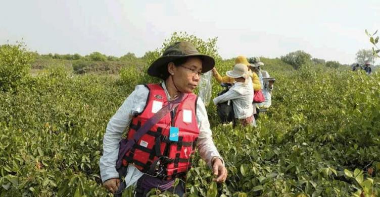
This story started at the beginning of 2017 when villages started to plant some mangroves in one small area near the coast of Thaton township in a small fishery village called Aung Khan Thar. During that event two ministers, local elected parliament members, state and district level department heads actively participated. It was the start of a change in communication between local community and the local government in that area.
One critical thinking person in Aung Khan Thar, U Myint Oo, strongly believed in the protection of natural resources and mangroves since he knew from experiences that these habitats are critical in the support for livelihoods of small fishermen and landless families. U Myint Oo was really concerned about his surrounding community, in which many villagers had a daily battle to survive because of lost fishing grounds and land near the coastal area of Thaton township.
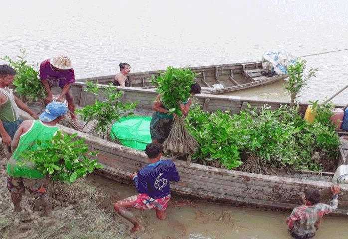
They identified an area of newly formed land near the coast where they went fishing daily. They also observed that this new land grows fast and supports food for the mud crab which could become a source of daily income for the people who do not own boats. In order to protect these resources for a sustainable improvement of their livelihoods, they proposed to identify an area as co-management zone for both the fisheries and forest sector. They requested the Mon state government to authorize to use the land as a co-management zone for the local community. The government gave the authorization and community declared the Aung Khan Thar Co-management zone on 16th Oct 2017. The people from the local community were very proud of this achievement and in their view created a brighter future for themselves and their children. Their dream became true.
However, conflicts started one year later, when new livelihood opportunities were identified by multiple government departments and local business people from surrounding areas. It wasn’t clear to whom the land was allocated and several government departments were in charge of this allocation. During the early stages, the local community were not able to influence the land allocation in their favor and the local business people and administrator wanted to convert the whole area into new paddy land.
The local community and the Village Development Committee (VDC) consulted with the Gulf of Mottama Project (GoMP) team how to discuss how to overcome this issue using a conflict sensitive approach between the local business people, village administration structure and other related departments. The GoMP suggested to communicate with different stakeholders who were involved in the case. The GoMP facilitated community members to gather the right information and communicate the people-needs to the respective government administration bodies in order the reach a fair decision on the wise-use of natural resources on this newly formed land.
The GoMP facilitated technical support to measure the real situation of this newly formed land along the coast and developed appropriate maps to enable informed decisions on the allocation of these resources in a sustainable manner.
After this information gathering, the GoMP facilitated a public meeting in Aung Khan Thar where other people from surrounding villages were invited. During this meeting they presented and discussed the plans for an environmentally wise use of of the area and a joint action plan was drafted for all the users of the area including the technical recommendation of the Forest Department and Department of Fisheries. This action plan was presented the the General Administration Department.
The leaders and villagers never gave up on their dream to protect their resources, which they value for their future use. Three village leaders worked together and agreed on the allocation of this newly formed land and they found a productive way to communicate this to the administrative body in order to stop the allocation of new land without public consultation.
Because of these efforts, the government responded with the following actions:
- To take a detailed measurement of this newly formed land by the District Land Utilization Committee.
- The measurement took into consideration the conservation purpose of the land and the Environmental Conservation Department took part in this measurement.
- The technical team submitted a report to the Mon State Cabinet for decision making.
After studying the report, the cabinet organized a public consultation during which it invited all the community members including farmers, fishers and landless people. The following agreement was made:
- To keep 9,000 acres as a mud crab protection area and mangrove plantation along the coast.
- 800 -1,000 acres of farmland, far from the coast, will be allocated to landless people who want to grow rice and other crops. This has still to be approved by the District Land Utilization Committee.
- To develop detailed maps for the protected areas and boundary stones to clearly identify the protected areas.
After the decision by the State Government, the local villagers made the demarcation stones and carried them to identify the boundaries of the mangrove plantation and mud-crab protection area for everybody to identify these areas.
This is the first community-lead land allocation exercise in the area. It became possible through a careful and evidence-based advocacy approach, which formed the basis for the collaboration between stakeholders in a positive manner. The Government had a good learning experience on how to collaborate among different departments and start the formation of a Working Group at township level of the Coastal Resource Management Committee. This incident showed all involved the importance of integrated management of natural resources and how collaboration reduces the risk of conflicts in the daily work.